Italy 2012
Even before I bought my motorbike I had in mind to ride on the old military roads in northern Italy. I began planning the details after my Easter trip to Czech Republic. Which road should I take to get to Italy, should I take the same one back, where will I stay at night, what should I take with me? There were a lot to think about ...
After reading Denzel, a guide for the Alps, and watching a couple of videos on Youtube, I had a huge variety of tracks to choose from. And I only concentrated on the area from Turin to Cuneo. I decided to look for a camp ground which was close to most of the roads. Camping Libac was located perfectly for that. It is a rustic camp ground in the small village Pontechianale at 1600m altitude. I was going to leave most of the equipment such as cases and my tent there. This way I wouldn't have to worry about setting up the tent every night, which can be quite annoying and the only thing to do after a tour would be cooking a delicious dinner. After my plan was fix I posted them at the 800GS Forum to see if someone might want to join me. The members "Susanne" and "Sprinter" liked my idea and wanted to accompany me for a couple of days.
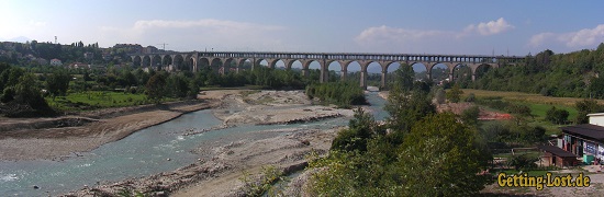
After weeks of anticipation the trip finally started on 01.09.2012. I started to roll with a cloudy sky around 8 am. Finally I escaped the daily routine again. For the next 21 days it will only be my bike and I! I drove on the Autobahn for the first 150km to the Thuringian Forest to cover some distance, from there it was only country roads. At Schwarzbachtal I ran into "Tokiomann", another member of the 800GS Forum, what a coincident. After a short chit chat our ways separated again and I continued on my way to the Alps. I needed to get a little further. Around 7 pm I arrived at my camp ground Cimbria. I set up my tent quickly and enjoyed the sunset while eating meat salad and a bear for dinner. It was a pleasant ending of my first day.
The next morning I started to ride in the direction of the Black Forest with a crystal blue sky. After 2 hours I stopped for a delicious breakfast ... pretzel and Redbull. My goal for the day was to reach Zurich. Around noon the sky became cloudy and the temperature dropped to 10°C. I didn't have to wait long for the first rain. When I arrived in Zurich it at least stopped raining.
I stayed 2 nights at my friends place (Thank you Shina for the great time!). From Zurich there were another 600km to accomplish. The first 250km I drove on the Autobahn via Bern to St. Bernhard. It was a wonderful pass with lots of turns and amazing views. Still amazed by the winding road through the mountains I rode in the flat and dull landscape of the Po-lowlands. But at least it was warm there. Considering it got late, I went back on the Autobahn. What a fun with all the tollbooths: driving up, taking of the gloves, getting the wallet, throwing change in the machine, restoring the wallet and putting on the gloves ... and repeating it after every 10km. Only 80km away from the camp ground I had to cross the border to France and shortly back to Italy. It was the last pass before getting in my cozy sleeping bag. The temperature was around 2°C and I was exactly 15km away from the camp ground when it started to rain and snow. The turns started to get interesting by then at 2700m altitude. It was already dark and I was soaked by the time I got to the camp ground. I checked in and then I had to set up my tent while it was poring down rain. It wasn't too bad because the temperate at least rose up to nice and warm 5°C.
I didn't sleep well at all. I think it was because the comfort temperate of my sleeping bag is at 9°C and everything was damp. I covered myself in my towel and an old bed sheet and tried to find some sleep. When I got up I wasn't in the best mood. For breakfast I took a triple Espresso and two croissants filled with jam. It was a rainy day so I decided to stay at the Café of the camp ground and wait for my friend "Susanne" who wanted to join me for a couple of days. When she arrived it stopped raining so was able to set up her tent in the dry ... lucky her. By the time everything was done it was too late to go on a ride. So we cooked dinner instead, had a glass of whiskey and made plans for the next day. We wanted to go on a tour up in the mountains.
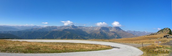
Assietta mountain road
The next morning we had a perfect blue sky. Suddenly the cold of the last two nights were forgotten, instead I was pleasantly anticipating the gravel roads. For the first day I choose the Assietta Road because it is a dirt road easy to drive on without big differences in altitudes. It is just perfect to get used to driving on such roads again. Starting from the camp ground I drove north for about 2.5 hours on three beautiful passes. The Assietta itself were in really good condition and the view of the mountains nearby was just beautiful. I can recommend this route to people without a lot of driving experiences on dirt roads.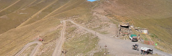
Maira-Stura mountain road
The weather on the next day was great again. In the morning the temperature was around freezing point but it got up to 12°C pretty quickly, in the valley at noon it even reached 25°C. We reached the Maira-Stura Road pretty quickly via a small mountain road. A nice couple from Belgium accompanied us and we drove the first half of the Maira-Stura together. Right at the beginning of the sign of the road the gravel fun started. It took us passed mountain pastures and over hilltops and it was only slightly more challenging than the Assietta. There were a lot of side roads and quite often we had to guess which route to take. If we really took the right ones I still don't know and probably never will.
Varaita-Maira mountain Road
It was day 8 and the last one before Susanne had to leave to go back home. We chose the Varaita-Maira Road which fit my taste perfectly. The first couple of kilometers were loose smooth gravel. After passing the prohibition sign the level of difficulty rose. At first it was loose wet forest ground, later on big rocks and 10-15cm high rock steps were added. It demanded our full concentration. In the afternoon it started to get cloudy and it looked like it would start raining soon. Luckily we reached our camp ground dry but pretty exhausted. It was a great tour!
The next day was calling for relaxation. It was day 9 and Susanne left in the morning to drive back home. I enjoyed the day in the sun with a good book in my hands. In the evening I cooked Pasta again on my camping stove. Vacation can be great!
The next day, 10.09.2012, the next visitors arrived. It was "Sprinter" who I knew from the 800GS Forum and we have met before on other occasions. After lunch we decided to go on a quick tour. It was Varaita-Maira for the second. The weather was great and considering I knew the way we got there fast. The road seemed to be no problem for "Sprinter" who has good experiences driving off-roads. It only took us 2 hours for the road, on the way back a rain shower surprised us. Soaked but happy we reached the camp ground right around sunset.
La Colletta
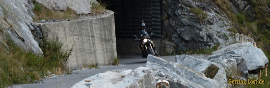
The goal for day 11 was to drive our first SG 5 road of our tour (SG is the Denzel-Scale). La Colletta turned out to be one of the nicest roads of the whole tour. At first a small gravel road ran parallel to a creek in the valley and passed a small chapel, you already could see the end of the stage in the distance. It got a bit more challenging. More and more rocks were right on the road and electric fences blocked the path. The condition of the track changed from smooth, dry gravel to rough and wet. The highlight right before the end was crossing a 30 meter long field of shale debris. Ending at 2800m altitude we got rewarded with an extraordinary view, two old bunkers and an old shed out of the times of World War II. On our way back to the valley I managed to check out what the road looks like laying down on it. What a beautiful day!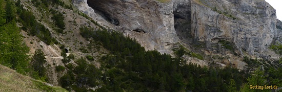
Monte Jafferau
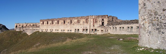
I drove on Monte Jafferau twice. The first time was on day 12 (12.09.2012), the second time on day 17. As usual we left the camp ground early in the morning. The cloudy sky didn't look too good. A couple of passes led us in 3 hours to Monte Jafferau. It took us so long because of rain showers that came now and then. We had a short break at the foot of the Jafferau, the rain had stopped only for a short while. In spite of the bad weather, we still wanted to go up that mountain. At least we were covered in our rain suits. The loose and wet ground was pretty slippery. Some other motorbike drivers were shaking their heads when they so us driving up. We were the only ones who tried to get up in this weather. The higher we got the lower were the temperatures sunk and the stronger rain and wind got. We reached the top (2801 meter altitude) with icy rain and only 2°C. Luckily old military ruins offered some shelter against wind and weather. "Sprinter" and I were happy to have in spite of the weather a great day trip. Back at the camp ground we spend the night with a couple from Berlin who were also there with their bikes. Time just flew by with wine and pleasant conversation. Thank you.
For the second Monte Jafferau trip you will have to go to day 17.
Colle di Gilba
Day 13 was the last day for "Sprinter". We chose a road nearby the camp ground. The Colle di Gilba is a wonderful small pass with a view over the Po-plain. The agricultural road is mostly used by farmers and in bad condition. Rough gravel with huge rocks caused sweat on our foreheads. After one hour we already reached the end of the road. We decided to just take the same way back as we came. Later at the camp ground we enjoyed "Sprinters" last evening with Pizza and wine and talked about stories about our former trips.
Ligurian mountain road
Day 14. The night was unbelievable cold. It was the first time that I had ice on my tent. I was more than happy to have 2 felt blankets to lower the comfort-temperature of my sleeping back from 9 to 0°C. Even after sunrise the temperature was below zero. After saying goodbye to "Sprinter" I went in the southern direction. The Ligurian mountain road was the main reason for my travel to Italy. It took me 4 hours to reach the southern end of the LGKS. After a delicious lunch in a small bar I had 63km gravel road right in front of me. It slowly went uphill to 1500 meter on rough gravel. Wide open grassland and forest took turns. I just had to stop over and over again to enjoy the landscape. This old military road was in good condition so I reached the timberline quite fast. The temperature up there was only around 10° C, at lunch time it had been 25° C! But the sky was blue and the sun was out. After 2 hours I passed the alpine hut that marked the middle of the road. There I met three other german Motorbike riders and by coffee and coke we were chit chatting. One of them even recognized me as "Luz", my name in the 800GS Forum. We took a picture of us together and they continued driving. I on the other hand enjoyed the fresh air and sun a bit longer before starting the north stage. Shortly after, the old road got pretty rough. 10 cm rock steps were no curiosity. After a while I met the three Germans at the Cold de la Boaire again. It probably is the spot of the LGKS that is the most impressive because it just drops down almost vertically. We decided to continue the road together in the direction of Fort Central, the end of the LGKS. It really is a beautiful road and I would definitely ride on it again. It is not too challenging and a perfect mix of landscape and fun. Also the length of the track makes it to a "Top Off-roads" in the Alps.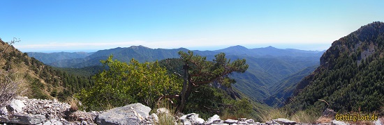
The next two days I stayed at the house of my relatives in Cuneo. I want to say "Thank you very much for the great time I spent with you!"
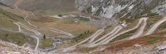
Monte Jafferau and Col de Sommeiller
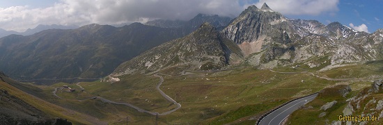
On day 17 of my trip I went on Monte Jafferau again. The first time I went up there the weather was pretty bad and you could not see 100 meter in a distance. But this day it was sunny and in good mood I went on my way. The 3 hour way via the French passes already were a delight. Starting in Salbertrand the direction was straight to the top of the mountain. On the way up I met again people I know ... the three Germans I met 3 days ago on the LGKS. We continued together on the winding road. The temperature was at pleasant 10° C and the view from the top was amazing. Because of the good weather conditions we decided to also go on the neighboring Col de Sommeiller.
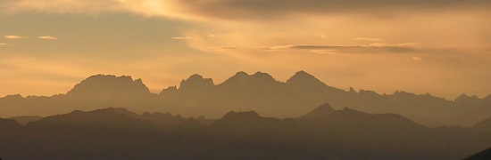
To go there we had to get back in the valley first. After finding the right way to Sommeiller, a paved road led up pretty fast. Of course, the asphalt ended after a while and a winding road of gravel went further up to the top of the mountain. This part was pretty challenging because of a lot of steep turns and the ground got rougher and rougher. Above 2600 meter in altitude I felt the exhaustion and with increasing altitude I started to have trouble to concentrate. Maybe it was because I already rode my bike for 7 to 8 hours this day or that we passed 2000 meter in altitude in only 30 minutes. Or maybe it was caused by the fact that I didn't have anything for lunch. Either way the last 400 meter altitude were a strenuous effort. Completely exhausted but happy, I reached the highest point that is fit for traffic by motorbikes that I have ever been to. My strength returned after a long break with water and plum cake and I began to explore the top plateau. My companionship already went on their way back down. 30 minutes later the sky started to cloud up again. It was time to go back. The way via the passes to France already started to feel familiar. Right before the camp ground the sun came out again to say goodbye to the day. I was on top of the Colle Dell'Agnello at 2746 meters and watched the sunset. It was one of the nicest sunsets I have seen and just the perfect ending of a wonderful vacation.
The way home
I was on the road for 18 days by now. It was time to go home. After packing up and having breakfast I cleaned up as one of the last people there. I said goodbye to the owner couple of the camp ground and started my way back home. This time I drove through the Po- plain on the country road. To cross border to Switzerland I choose the Simplonpass and via the Furka road I drove to Zurich. Shina was so kind again to let my stay for two more nights ("thank you again Shina"). From Zurich I drove to Austria because I spontaneously made plans to meet 2 friends of mine to eat "Schnipo" at the highway. From there I took the Autobahn most of the time to get home.
Fazit
The regions Peimont and Ligurien are a dream for everyone who loves the mountains. They are wonderful and I can definitely advise to spend their vacations there, no matter if by foot, by bike or like me, by motorbike.
Luz


